Scan to BIM London
PointBIM delivers Scan to BIM services across London, producing accurate Revit models from laser scans for architects, developers and contractors. Our models provide a reliable digital record of existing buildings — from heritage properties and townhouses to large commercial refurbishments — enabling confident design and coordination.
All modelling is completed in-house by Autodesk Certified Professionals. We take pride in the clarity of our work: geometry is clean, structured and true to existing conditions. Where required, we create custom Revit families for elements that standard components don’t represent well. This ensures the final BIM model is both accurate and efficient for design teams to use.
We complete Scan to BIM projects across Clerkenwell, Farringdon, King’s Cross, Shoreditch, Fitzrovia and Canary Wharf, reflecting the variety of London’s built environment. Each survey is captured using high-accuracy laser scanning, then modelled to clearly defined LOD and RICS specifications, aligned to OS grid and site datum when required.
The result is dependable BIM data that integrates cleanly into architectural and engineering workflows — ready for planning, refurbishment and asset management.
Below are examples of our recent Scan to BIM London projects, showing the range of buildings and modelling detail PointBIM delivers: from multi-storey commercial buildings to listed façades and workspace refurbishments.
We provide Scan to BIM services throughout London, creating accurate Revit models from laser scans — all completed in-house by Autodesk Certified Professionals. Our models use clean geometry and custom families to reflect real-world conditions, providing dependable data for refurbishment, coordination, and design development. Below are examples of our Scan To BIM projects across London’s key districts.
SCAN TO BIM SURVEY LONDON : Shoreditch EC2A
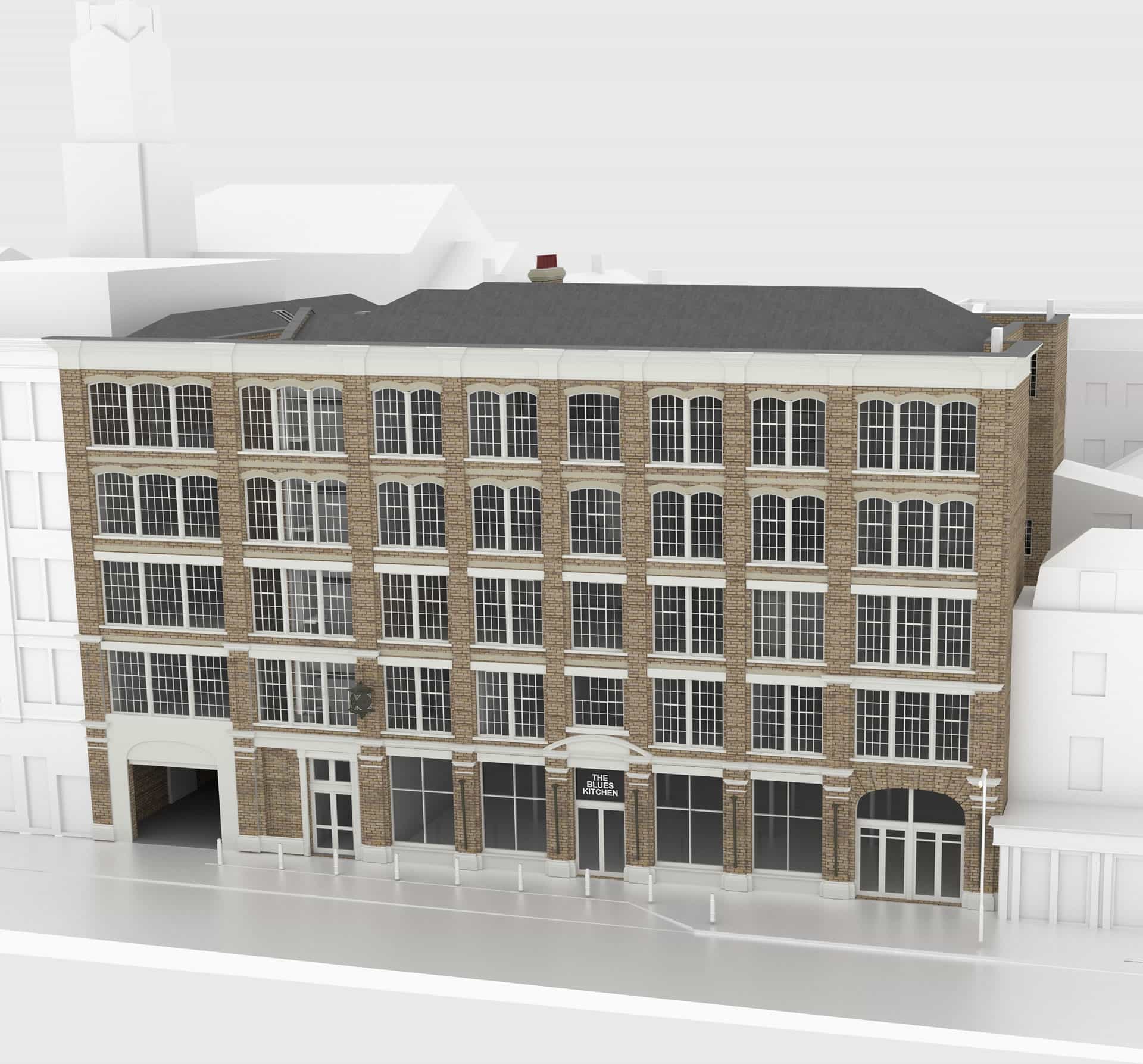
This former warehouse in Shoreditch is typical of East London commercial stock, with mixed structural systems and irregular internal geometry shaped by incremental alterations over time.
A full laser scan survey and BIM model were required to support early-stage design and refurbishment planning, providing a reliable digital base for feasibility and coordination.
High-accuracy terrestrial laser scanning was used to capture the building geometry in full, with the survey data processed into a clean, well-structured Revit model aligned to the project coordinate system. Key architectural and structural elements were modelled to a level suitable for planning, design development and future refurbishment phases.
A Scan to BIM survey of a large warehouse conversion in Shoreditch EC2A, near Curtain Road and Standard Place. The buildings were laser-scanned and modelled in Revit to an enhanced LOD 3 specification, providing accurate as-built data for refurbishment and design coordination.
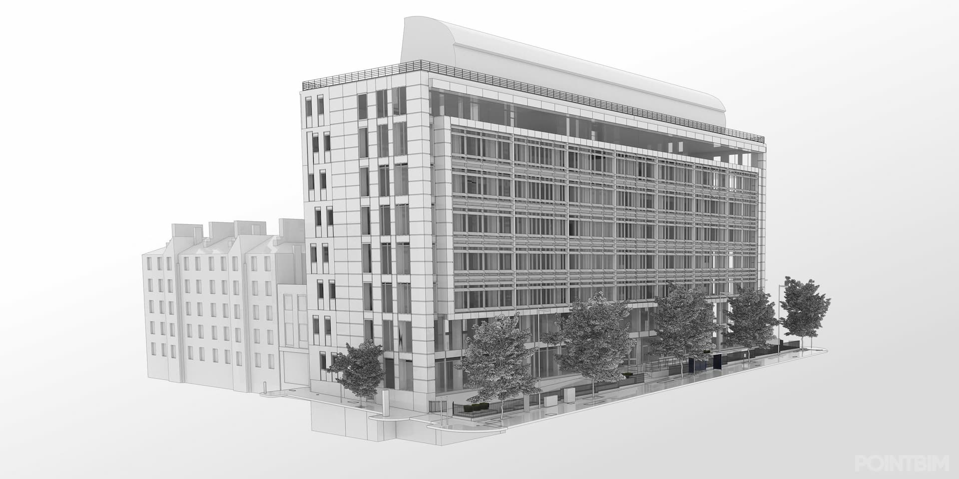
SCAN TO BIM LONDON : Commercial Building, King’s Cross / Pentonville Road N1

This multi-storey commercial building in King’s Cross required a complete Scan to BIM package ahead of refurbishment. The project involved capturing core areas, floorplates, façade lines and complex plant zones on the roof.
Laser scanning was carried out across all accessible areas, with internal vertical circulation spaces captured in detail to support future fire strategy and MEP coordination. The Revit model was structured for use within wider consultant workflows and referenced to OS grid and site datum.
The final BIM model enabled the project team to progress confidently with design development, providing reliable geometry for tender and contractor engagement.
A Scan to BIM survey of 210 Pentonville Road, King’s Cross — a modern office building captured in full detail for refurbishment and services coordination, with an accurate Revit model created from registered laser scans.
SCAN TO BIM LONDON : Cavendish Place, Fitzrovia W1
This period townhouse in Fitzrovia required a detailed BIM model to support architectural refurbishment and interior reconfiguration. The building included heritage features, non-standard room geometries and mixed floor construction typical of West End properties.
PointBIM scanned the building throughout, including stair cores, basement spaces and roof structure. All features were modelled cleanly in Revit, with custom families created where standard components did not represent existing conditions accurately.
The completed model provided a dependable foundation for design, enabling the architect to assess structural constraints, service routing and proposed layout changes.
A Scan to BIM survey of a West End period property near Oxford Circus, laser-scanned and modelled in Revit to an enhanced LOD 3 specification for refurbishment and coordination within a constrained central London site.
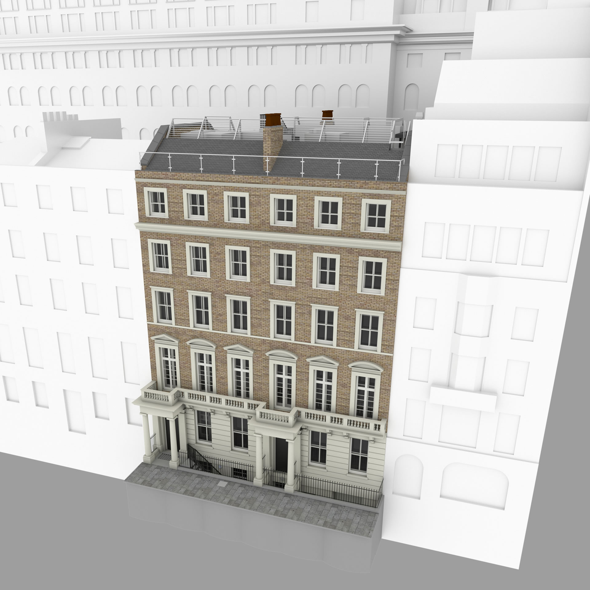
SCAN TO BIM LONDON : Bedford Square, Bloomsbury WC1B
This project involved producing a precise Scan to BIM model of a historic Bloomsbury property facing Bedford Square. The building included listed-façade elements, high-ceilinged rooms and varying floor levels, requiring careful capture and modelling.
The site was scanned externally and internally, including attic spaces and rear extensions. The Revit model followed clearly defined LOD and RICS Band E requirements, ensuring geometry was accurate, structured and usable for planning and heritage discussions.
The resulting BIM data supports architectural design, conservation work and long-term asset management across the wider estate.
A full-colour Scan to BIM survey of 34–36 Bedford Square, Bloomsbury WC1B, capturing three listed Georgian townhouses and producing a detailed Revit model to enhanced LOD 3 for refurbishment, conservation, and facilities planning.
Frequently Asked Questions
Yes. We regularly work across Central and Greater London, including Shoreditch, Farringdon, King’s Cross, Fitzrovia, Bloomsbury, Clerkenwell, Canary Wharf and the West End. Projects outside central zones are also possible depending on access and survey scope.
For a laser scan / pointcloud only service please see below
For scan to CAD surveys in London please check the link below
Can We Help with Your Next Project?
Whether you need a quote, a tender submission, or just advice on how to scope your Revit or CAD survey — we can help.
Send us your drawings, a short brief and a site location and we’ll get back to you with a fixed price.
Clear answers, honest pricing, no obligation.
For UK Quotes Call Ryan +44 7725 236671